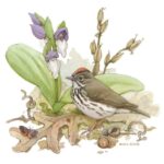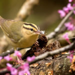
OOS Warblers and Wildflowers Weekend 2022
OOS Warbler and Wildflower Weekend
OOS Warbler and Wildflower Weekend
Ohio Bird Records Committee Summary 2021
The Ohio Bird Records Committee (OBRC) had a productive year in 2021. Due to a complicated series of circumstances, the committee had not functioned effectively for several years. Late in 2020, OBRC founder Robert Harlan asked Jon Cefus if he was willing to take the role of secretary in an effort to try to get the committee functioning again. Jon Cefus agreed to take the role of secretary with Robert Harlan in the role of vice-secretary to help facilitate the process and provide guidance about procedures and adherence to the OBRC bylaws.
The membership of the committee in 2021 included Jon Cefus (Secretary), Robert Harlan (Vice Secretary), Jen Brumfield, Tom Kemp, Steve Landes, Ben Morrison, Steve Schafer, Ben Warner, and Brian Wulker.
The first task for the secretary and vice secretary was to determine if the current members of the committee were willing to continue their tenure. All the members agreed.
The second task was to prioritize what records should be reviewed as there was a growing number that had not been addressed. The secretary and vice secretary deemed that new state records in Ohio should be the first priority. The second priority was to review records that would have an impact on the presence of rare species in Ohio since the last publication of The Ohio Bird Records Committee Annotated Checklist of the Birds of Ohio in 2008, as there is intent to publish an updated edition of that checklist in 2022.
Integral to achieving the above goals, it was determined that some emendations to the OBRC bylaws would be necessary. A proposal was put forth to emend the Bylaws of the OBRC to better reflect recent trends in observations of birds in Ohio and to help the records committee work more efficiently. In the past, the threshold for a species to be removed from the review species list was that the accepted record frequency was fewer than TWO records per year for the most recent 10-year period. A vote was taken, and the following emendation accepted by the committee establishing the criteria of an Ohio review species as:
“Review List criteria are as follows:
(a) Any species for which there is no Accepted record for the state is automatically a Review List species;
(b) Any species for which the Accepted frequency is less than ONE record per year (for the most recent ten year period) is automatically a Review List species;
(c) Any species not falling within the above two categories may be added to the Review List, after relevant discussion, if a majority of the Committee so agrees.”
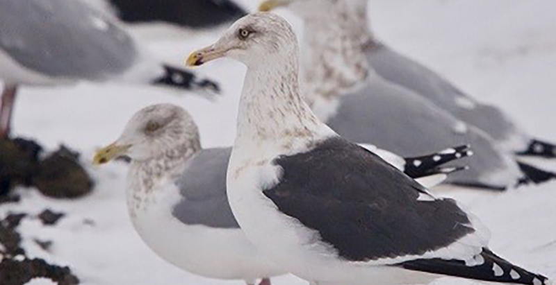
The first batch of records to review was sent to the OBRC in March 2021. This batch of 20 records represented 10 new potential state records, as well as several 2nd and 3rd state records. The committee unanimously voted to accept all 10 of the new state records, bringing the official list of accepted species in Ohio to 443 and a species pair. The 10 species added to the list of OBRC accepted records in Ohio are:
Black-chinned Hummingbird, Limpkin, Slaty-backed Gull, Brown Booby, White-tailed Kite, Tropical Kingbird, Gray Kingbird, Chestnut-collared Longspur, Brewer’s Sparrow, and Hooded Oriole.
The emendation to the bylaws that set the standard for what constitutes a review species for the OBRC (see above) resulted in 22 species being removed from the review species list in 2021. The 22 species are:
Black-bellied Whistling Duck, Trumpeter Swan (a separate vote covered below), White-winged Dove, Yellow Rail, Piping Plover, Ruff*, Black-headed Gull, California Gull, Pacific Loon, Neotropic Cormorant, Brown Pelican, Glossy Ibis, White-faced Ibis, Mississippi Kite, Loggerhead Shrike*, Fish Crow, Cave Swallow*, Varied Thrush, Smith’s Longspur, Harris’s Sparrow, Kirtland’s Warbler, and Painted Bunting.
In the list above, the (*) indicates that the committee voted to place that species, which had met the threshold for removal from the review species list, back on to the list of review species in Ohio. For Ruff, the rationale was that it remains a rare bird in the American Birding Association Area in North America. Loggerhead Shrike populations continue to decline in our part of the country. Cave Swallows are generally seen over Lake Erie at long distances in the late fall/early winter, presenting challenges getting to a definitive identification.
The OBRC continued to vote on batches of review species through 2021. In the end, the committee voted on 6 batches of review species. The batches added up to reviewing 127 records. These records were gleaned from 2 sources. The first source is the OBRC portal provided by the Ohio Ornithological Society’s website. Those records were sent to the OBRC by individuals who saw a bird and sent written documentation about their sightings. If needed, supporting documentation (e.g. photos, audio recordings) was sent to bolster the report. The second source are reports generated in eBird by observers using that citizen science tool. Many eBird users take photographs or make recordings of their sightings, particularly of rare birds, which are often review species in Ohio. In order to help facilitate the work of the secretary at gleaning these review species reports, the team of eBird reviewers in Ohio are asked to find the best reports in their respective areas of review species and submit them to the secretary to be entered into batches of records to be reviewed. The trend seems to be that birders are using less paper submissions of review species to the OBRC (and presumably other state records committees), so finding ways to get reports via sources like eBird will be essential going forward.
Of the above 127 records reviewed by the OBRC in 2021, 123 were accepted by the committee votes. 3 records were not accepted. 1 record was placed into recirculation status and remains unresolved as of the generation of this report. The committee will continue discussion about this record in 2022.
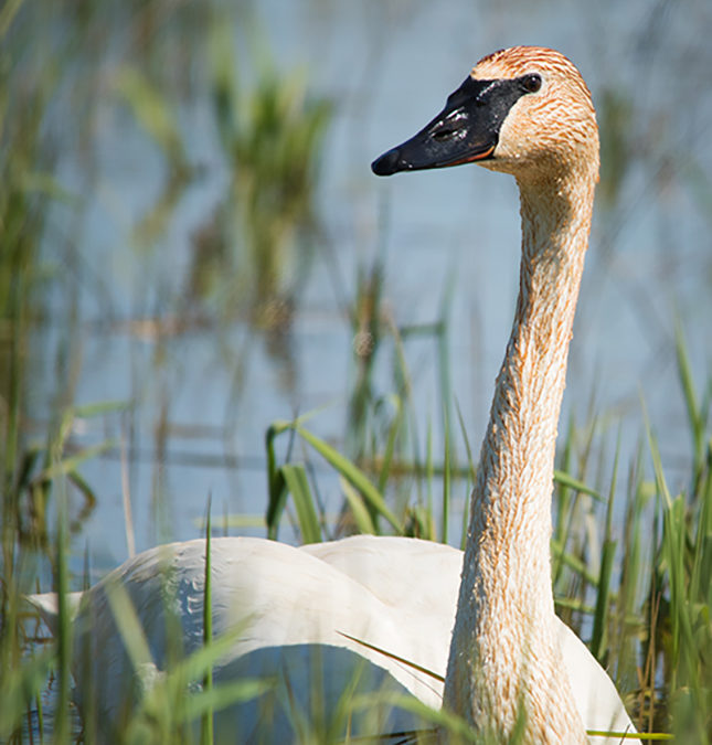
In addition to casting votes on the above records, the OBRC also met the goal of taking up the question of whether to remove Trumpeter Swan (TRUS) from the list of review species in Ohio. After gathering information regarding the status of TRUS in Ohio historically, its introduction to the state in 1996, and its breeding status/presence since that year, the committee voted unanimously (9-0) to remove it from the list of review species in Ohio. The evidence is clear that TRUS has successfully established a presence in Ohio. A more detailed report discussing the full rationale was published on the OBRC Facebook page and posted on the Ohio Birds email listserv. An article is also being published in the Ohio Cardinal, the repository of Ohio’s birding records.
In regard to the coming publication of a new Ohio Bird Records Committee Annotated Checklist of the Birds of Ohio, author Robert Harlan reported to the secretary on December 2, 2021 that his work gathering the most up to date data for that project was complete and he, with a great deal of assistance from his wife Sandy, had completed the bar charts for that publication. The secretary will now find someone who can take that data and the bar charts and put them into a format for publishing as a physical handbook. The goal is to have this handbook available in the spring of 2022. The Ohio Ornithological Society agreed several years ago to pay the costs of having this new annotated checklist printed.
The final business attended to in 2021 was to find replacements for the 2 committee members whose terms are ending at the end of this calendar year. Tom Kemp and Ben Warner have both contributed a great deal to the committee and brought their experience and knowledge to bear on all the committee’s endeavors. The committee hopes that they will both return to serve in future years. Thank you, Tom and Ben! Nominees were presented to replace these 2 coming vacancies. Alex Eberts and Matt Kemp were nominated by committee members and a vote was taken to accept them as the newest OBRC members. The OBRC voted unanimously to accept their nominations. Thank you to Alex and Matt for their willingness to join the OBRC!
The Ohio Bird Records Committee looks forward to continuing our work in 2022.
Jon Cefus
Secretary, OBRC
Each month, our OOS Regional Directors are sharing their favorite birding hotspots in their respective regions – and beyond. These include some well-know destinations, specialty spots for specific species, and their own secret, treasured local patches. Have a favorite birding location? Reach out to your OOS Regional Director and let them know!
Trumbull County is an underrated county in Northeast Ohio with a lot of public land and excellent birding. In December you will find me birding around Mosquito Lake, which is the most popular birding hotspot in the county, and for good reason!
Ohio’s second largest inland lake, Mosquito Lake is just shy of 10 miles long from north to south. Mosquito Creek Wildlife Area encompasses the north end and offers excellent viewing opportunities for wintering raptors, large numbers of waterfowl, and typically hosts at least one Northern Shrike every winter.
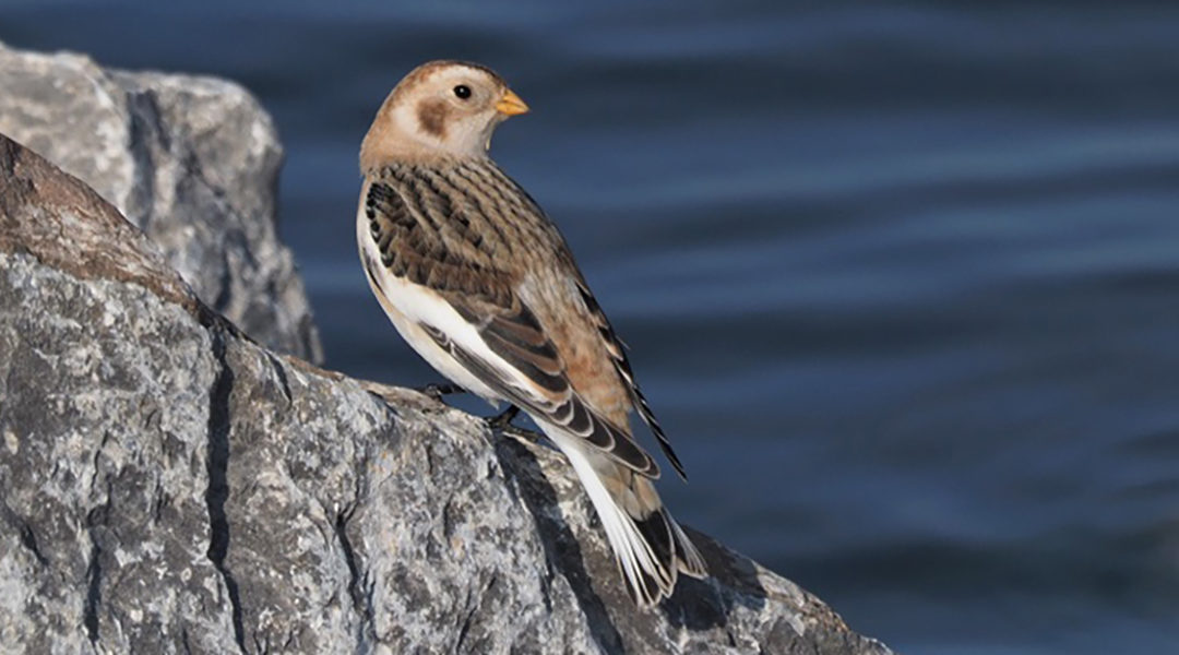
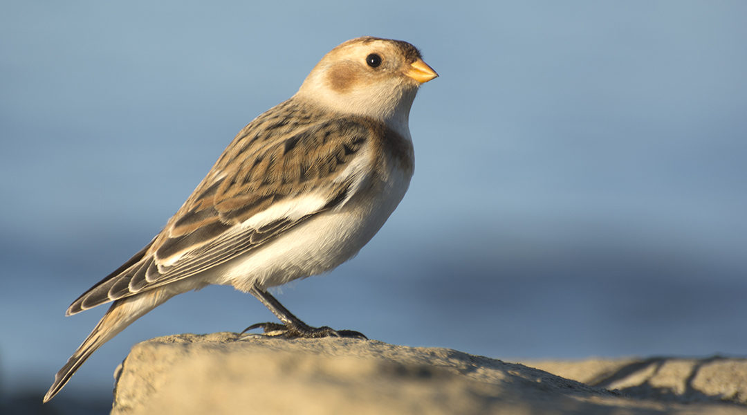
The causeway that bisects the lake to the south offers more waterfowl viewing opportunities, Snow Buntings most winters, and the occasional Snowy Owl. At the south end of the lake, you will find Mosquito Lake State Park, which offers hiking trails and a beach area, which sometimes hosts interesting gulls.
If you’re up for a good winter hike for birding, the Turkey Run Trail on the east side of the lake is well recommended.

RECENT OHIO BIRD RECORDS COMMITTEE ACTION REGARDING THE STATUS OF TRUMPETER SWAN IN OHIO
In October 2021, the nine member peer-review panel Ohio Bird Records Committee (OBRC) voted unanimously to remove Trumpeter Swan from it’s list of Review Species in Ohio, determining that the species is now firmly established here, and is likely to remain as an Ohio resident. Details of this decision, the thought process behind it, and the current status of Trumpeter Swan in Ohio, follows.
The true status of Trumpeter Swan has long perplexed naturalists in Ohio, but we are not alone…the same is true throughout much of eastern North America. Since the earliest days of journaling and record keeping, the species has been the subject of conflicting reports, but little hard evidence, across this large area. For thorough and well-researched background information, prepared in large part for this Committee years ago by the late Bill Whan, see the articles linked at the end of this review.
In short, there is no direct evidence which indicates that Trumpeter Swan ever nested in Ohio historically, although it certainly was at least a rare migrant through the 1800s.
Trumpeter Swan is already Accepted on the Ohio list (based on historical data) by the OBRC, and has likewise long been accepted by earlier authorities. This Committee recognizes the last wild Trumpeter Swan in Ohio as being shot in Jackson County in April, 1900. In this case, “wild” pertains to an individual emanating from a naturally occurring population. Due to its nearly 100-year absence as a wild species in Ohio, Trumpeter Swan has therefore held a place on the OBRC’s Review List, and received special attention, since the Committee was formed in 1991.
In 1996, however, the Ohio Division of Wildlife, in cooperation with other partners, and in the pattern of other state and provincial wildlife agencies nearby, introduced Trumpeter Swan into Ohio with the intention that it would become a permanent part of Ohio’s avifauna. This action, of course, added a layer of complexity which affects our abilities to discern the potential “wildness” of Trumpeters seen here…as numbers of Ohio-introduced Trumpeters, their progeny, and introduced and reintroduced emigrants continue to increase here, our ability to detect and discern birds potentially from naturally occurring populations continues to decrease to the point of becoming practically unachievable.
Nonetheless, the OBRC has retained Trumpeter Swan on the Review List until now, in hopes of gathering data on any potentially wild individuals, but also more realistically to gather information on introduced populations as they might fare locally after direct human intervention had ended. Over 25 years have now passed since introduction efforts began here in Ohio, and patterns of occurrence have emerged.
Therefore, it seemed appropriate for this Committee to reassess the data concerning the current status of Trumpeter Swan in Ohio, and to vote whether to retain or remove the species from the Review List. A vote to remove would result in the species no longer receiving special treatment by the Committee.
We have gathered data from numerous sources, including publications by the Ohio Division of Wildlife, eBird, the monthly bird census at Ottawa National Wildlife Refuge, The Ohio Cardinal, and numerous knowledgeable individuals. We are especially grateful for the tireless work done by former OBRC member Dan Sanders on the Committee’s behalf, with his careful determinations of nesting successes of swans across the state.
OHIO DIVISION OF WILDLIFE RELEASE EFFORTS
According to Laura Kearns, Wildlife Biologist with the Ohio Division of Wildlife, 15 Trumpeter Swans were released at Magee Marsh Wildlife Area in 1996. Additional releases occurring from 1997 to 2003 placed birds at a total of 11 Ohio sites considered to be suitable wetlands, with approximately 150 birds being released in total. By 2003, 15 breeding pairs statewide fulfilled goals which allowed for a discontinuation of release efforts by the state, although other licensed propagators still exist locally.
Monitoring continued, and by 2013 fulfilled goals (including 35 breeding pairs) allowed Trumpeter Swan to be shifted from the state’s Endangered List to it’s Threatened List, according to ODOW guidelines. By July 2014, the ODOW tallied 246 individuals statewide, with nearly 140 cygnets being produced in that year alone, and with new locations being utilized by nesting pairs.
Numbers continue to increase, according to the ODOW. By 2020, 98 pairs were surveyed statewide with 235 cygnets being raised. Over the previous five years, the state averaged a 14.7% increase in raised cygnets, but in 2020, that number increased to 19.9%. The total population of Trumpeters in Ohio in 2020 was estimated at 650 individuals, and in 2021, nesting pairs have surpassed the 100 mark. Nesting range has continued to increase as well, although peak numbers still reside in the northwestern Ohio Lake Erie marshes.
Also in 2020, 12 Ohio Trumpeters were fitted with GPS-tracking neck collars, and their movements, as well as the movements of over 100 other swans collared in five midwestern states and Manitoba, are now viewable online at <https://trumpeterswan.netlify.app/locations.html>. Although no ingress or egress of GPS-collared swans has been noted for Ohio (rather, only short-distance tracked movements have been noted here), longer distance movements in other areas indicate that given a larger sample size, movements into and out of Ohio could certainly be occurring (in fact, they are occurring– the Ottawa NWR monthly census has identified two Trumpeters, in 2019 and 2021, with unique wing tag markings establishing origins in Ontario, Canada).
According to the attainment of ODOW management plan goals, Trumpeter Swan is now eligible to be removed from the state’s Threatened List, although this has not yet occurred.
DATA FROM THE OTTAWA NATIONAL WILDLIFE REFUGE MONTHLY BIRD CENSUS
This census covers a prescribed route, and is run monthly year-round, through the marshes of Ottawa NWR in Ottawa and Lucas counties. Observers pay special attention to swan numbers of all three local species, and since 2007 have recorded any unique markings visible in the Trumpeters they see. As such, these surveys provide valuable year-round data, as compiled by the late Ed Pierce and Doug Vogus, who graciously has provided us with the information presented here.
One nesting pair of swans, “74M” and “1A2”, has been present there since at least 2007 (and are therefore at least 15 years old), all indicative of the nesting potential for this long-lived species in preferred habitat. Except for an outlier found in 1991, Trumpeters were first detected on the census in 1996, the first year of introduction at adjacent Magee Marsh. Since then, the species has been found there on almost every monthly survey date.
We can conveniently break down the census numbers as follows: during the 5-year period of 1996-2000, a total of 149 swans were tallied. In the next 5-year period, 2001-2005, 470 swans were tallied; from 2006-2010, 1032 were tallied; from 2011-2015, 1564 were tallied; and from 2016-2020, 6470 were tallied.
An average of 30 swans were tallied per year during the period of 1996-2000; 2001-2005 averaged 94 per year; 2006-2010 averaged 206 per year; and 2011-2015 increased the average substantially to 313 per year. Not until the 2016-2020 period did numbers skyrocket, averaging 1294 per year.
The maximum number of Trumpeters on any date was 408 during January 2020.
These numbers very clearly show an increase in Trumpeter Swans at Ottawa NWR, and parallel ODOW increases noted above.
DATA FROM THE OHIO CARDINAL AND EBIRD
From information compiled by Editor Craig Caldwell from eBird and other sources, we can break down data for the past 10 years since 2011. Observers in an average of 15 Ohio counties per season submitted Trumpeter Swan reports for 2011; by 2014, the average was 23 counties per season; by 2017, the average was 26 counties per season; by 2020, the average was up to 33 counties per season. For the Winter 2020/21 and Spring 2021 seasons alone, an average of 49 counties reported Trumpeters. Although an increased number of observers may account for at least a portion of this increase, it also parallels ODOW and ONWR census trajectories, and presumably indicates expanding range necessitated by increasing numbers.
COMMENTS FROM VOTING MEMBERS
Committee members were asked to comment on their voting decisions. The following comments are excerpts taken from the votes of various OBRC members:
1) “The issue of Trumpeter Swan has long been confusing for the public. It is now very well established here and should be countable without attempting to determine where it originated from.”
2) “OBRC’s initial intent of having Trumpeter Swan on the Review species list to gather info on potentially wild individuals seen in Ohio and to gather data on how introduced populations would fare after their introduction by humans was a sound policy. It seems unlikely that the OBRC could have foreseen how the numbers of Trumpeter Swans in Ohio would expand over the next 30 years from 1991 when it was added to the Committee’s list of review species….We then have a responsibility to inform and educate Ohio’s birding community about our decision and how it affects whether they can add Trumpeter Swan to their various lists in Ohio.”
3) “This is about a sustained, viable, and expanding population.”
4) “It is clear that Trumpeter Swans in Ohio are here to stay, at least for the foreseeable future. It is also clear…that it is now close to impossible to determine if any of the swans in Ohio are truly wild strays and not from the introduced population.”
5) “I vote to remove Trumpeter Swan from the OBRC Review List…it can be hard to predict how a species’ populations will change over time. But that’s perfectly okay. To paraphrase a saying, you go with the data you have, not the data you wish you had. If the situation changes, the question can be revisited.”
6) “Simply put, they have been here for more than twenty years…No longer is this species being supplemented by additional release efforts (for some time now) and they don’t rely on humans to continue surviving in the wild.”
7) “Voting [to remove the species from the Review List] is difficult for me since I never approved of the process that brought them here. So I will give the victory to the vibrant species, rather than the process. They are here to stay.”
ON COUNTABILITY IN OHIO
The issue of countability of Trumpeter Swan in Ohio has come up frequently over the years while the species has resided on the Review List. Although it may frequently be viewed as determining countability, the OBRC does not directly serve this function. Rather, according to OBRC Bylaws, the Committee 1) endorses records it determines to be suitable, based on the strength of available evidence, to be included in the historical record; 2) provides a means by which records can gain universal acceptance as scientific data; and 3) establishes standards of observation and reporting against which observers may compare their own techniques.
So, in reality, the Committee provides guidance on which birds it considers countable, but the actual determination to count is done by birders alone.
Birders have treated the countability of Trumpeter Swan in Ohio in a variety of ways. Some have waited to count Trumpeters for their Ohio lists until the OBRC determined that the species was established here. Others have waited to count the species based on interpretations of American Birding Association listing rules (although these rules have changed over the years and are not always easily interpreted). See for instance <www.aba.org/aba-area-reintroduced-indigenous-species/>, which seems to indicate that the ABA believes that Trumpeter Swan should already be countable in Ohio despite confusion over the matter of whether the species is truly indigenous here. Undoubtedly most birders using eBird to record their observations already count Trumpeter here because the platform allows them to be counted. Of course, many birders and nature enthusiasts see a Trumpeter Swan and automatically count it, without considering any background information. Others have simply counted the species using their own inclinations and judgement.
With this vote, the Committee acknowledges the establishment of Trumpeter Swan in Ohio and hopes that the decision to remove the species from the Review List will also remove any questions of countability here.
Although differences of opinion exist regarding whether introduction efforts here were appropriate, one cannot overlook the increasing presence of Trumpeter Swans in Ohio’s wetlands. Further study is certainly warranted, if only to verify future population numbers, but more importantly to better establish how the presence of Trumpeters affects native species, both competing for the same limited tax dollars, and dwelling in the same precious habitats.
For the OBRC,
Rob Harlan, Vice Secretary
For background information, see:
Did Trumpeter Swans Ever Breed in Ohio?
by Bill Whan (2000)
<www.acsu.buffalo.edu/~insrisg/nature/whan_essay.htm> and a 2007 update
<www.acsu.buffalo.edu/~insrisg/nature/WhanTS07.htm>
Did Trumpeter Swans Ever Breed in Eastern North America?
by Bill Whan and Gerry Rising (2001?)
Each month, our OOS Regional Directors are sharing their favorite birding hotspots in their respective regions – and beyond. These include some well-know destinations, specialty spots for specific species, and their own secret, treasured local patches. Have a favorite birding location? Reach out to your OOS Regional Director and let them know!
As I come to the end of my 4-year term of East Central Ohio Regional Director for the Ohio Ornithological Society, I am spending a day birding in a county that is close to my heart. That county is Carroll. My family built a cabin on Leesville Lake in the early 1970’s and it has been one of my favorite places to be.
At one time, Carroll was one of the least birded counties in Ohio when looking at eBird data. In 2016, with the help of my friends Kent Miller and Ben Morrison, we surveyed that county for a full year and were able to add many new bird species to the county records. The following represents a typical route I might take in the month of November, which is often one of the more difficult months to find a good variety of birds, except for waterfowl, which tend to be moving through in good numbers in Ohio depending on weather conditions. For those who like to achieve a certain number of species in a given month, say 100 species for example, November can be a challenge, especially if you are limiting yourself to one county. In November of 2016, I saw 71 species in Carroll County. The following is rather lengthy, as I try to provide details about accessing public areas/roads that I have used over the years.
My morning will begin at Leesville Lake Wildlife Area located on Delta Road SW accessing it on Autumn Rd. SW. on the south shores of Leesville Lake. As is always the case when locating birds in the late fall and winter months in Ohio, I will be listening for Chickadees and Tufted Titmouse, as it is often the case that other birds that spend the winter in Ohio will be associating with them. These might include Golden-crowned Kinglets, Brown Creepers, and Red-breasted Nuthatch. If I find a group of such birds, I will also be paying close attention to see if a lingering Ruby-crowned Kinglet or Hermit Thrush is nearby. Another indicator of an area being productive would be seeing/hearing White-throated Sparrows, which also spend the winter months here. If you are hearing or seeing a nice variety of birds like the above, the habitat is likely holding good food choices for the birds, which provides you a chance of seeing something less common. I think of it like this: birds of multiple feathers flock together in winter in Ohio. This area is generally good for a nice variety of woodpeckers, including Downy, Hairy, Red-bellied, Pileated, Northern Flicker, and Yellow-bellied Sapsucker.
Viewing the water itself at Leesville Lake can be a bit of a challenge, but with patience you can work the available public road access points to get glimpses of the water and find waterfowl. If I begin at Leesville Wildlife Area (Delta Rd. off of Autumn Rd. SW), I will turn right as I leave the wildlife area on Autumn Rd. and go until it dead ends. There is a small pull off at the bottom that you can park at and step out of the car to see a small bay and a bit of the lake. It is a small view, but you are close to there so a quick look cannot hurt. From there, I am going back up Autumn Rd. to the next road on the right past Delta Road, which is Bramble Road. Bramble winds its way down towards the south fork of Leesville Lake. I will be listening for birds as I make my way down, stopping along the way if I hear a group that has potential.
When you hit the “bottom” of Bramble, you will come to an intersection that crosses a creek where Dove Road intersects with Bramble. I turn right on to Dove Rd. and follow it along the lake scanning for waterfowl and listening for woodland birds. It is a dead-end road, but winds nicely along the lake. After checking that, I turn around and go right on Bramble to continue my way along the lake, checking as I go. These roads are quiet and not very busy, but you should be mindful of not blocking other drivers. It is generally fine to be pulled off the right side if you need to stop to scope the lake or listen for birds. As you make your way along during the cold weather months, the lake will give way to becoming the trickle of McGuire Creek, which is the source of the Muskingum Watershed Conservancy District’s creation of Leesville Lake. You will pass Desert Rd. on your left and then come to another intersection with a bridge over the creek. That is Dew Drop Road. I like going up that road partly because of the name, and partly because it is more birding friendly than going out to SR 332 to make my way towards Leesville Dam.
Going up Dew Drop Rd. and birding along the way, you will end up hitting SR 164 (Amsterdam Rd.) where you turn right on that state route heading towards the little town of Leesville. A few miles down the road, SR 164 hits a low spot and you make a hard right turn. Just before you would turn around a hard left corner, a county road will be in front of you. This is CR 115 (Deacon Rd.) and I drive straight up Deacon. Along this section of road is mixed habitat. On your right is wooded areas made up partially of wildlife area around Leesville Lake, and on your left farmlands that often flood in the spring and fall, providing habitat for dabbling ducks, geese, and shorebirds (often wintering Killdeer are here). Eventually, Deacon Rd. opens up to farmland on both sides and becomes CR 22 (Azalea Rd.). Continue on Azalea in the direction you are traveling (basically north) past farms and private homes. The next road on the right, Deer Rd. (CR 116), will take you up to Leesville Dam.
There are a few pull offs along Deer Rd. if you should hear woodland birds you want to investigate. You will peak at the top of the dam as you drive up. You cannot park at that top area legally, but just down from the top on the left is another pull off, which allows a good place to scope the deepest part of the lake. This is where I will generally find diving ducks if they are on the lake. It is also an area that gulls gather. The wooded areas around here and up the road going into the campground and marina area have been productive for Red-breasted Nuthatches over the years. This is also a nesting area for Pine Warblers, so you might get lucky and find a lingering Pine Warbler along this stretch. Eventually, you will loop back around as Deer Rd. dead ends at the marina. I make my way back out past the dam and down Deer Rd. until it ends at Azalea Rd. and I turn right. After a very short distance, you cross the outflow of McGuire Creek from the dam on a small bridge and I turn left back on to Deer Rd. to make my way out along the creek to SR 212 (Cumberland Rd.). Watch for Mallards and American Black Ducks in the creek, especially if the lake is icy.
I turn right off of Deer Rd. on to SR 212 going towards the little town of Sherrodsville to make my way to Atwood Lake. Atwood Lake has areas in both Carroll and Tuscarawas Counties. If you want to be able to look at the deepest water area of Atwood, then checking the area by the dam is essential, and that area is in Tuscarawas County. I follow SR 212 into Sherrodsville and then turn right to stay on SR 212/SR 39 east. Go east through Sherrodsville and as you are leaving town SR 212 goes off to the left, take that left. You will go a few miles, past SR 542, and you will see the dam area with a sign at the access road to a large boat launch/parking area. This is a good spot to scope the west end of Atwood Lake, all of which is in Tuscarawas County. Generally speaking, most any bird you can make out with a scope looking east from the dam parking lot is in Tuscarawas County. The Carroll County line stretches across the lake near the Atwood Lake Park beach area, which is pretty far east up the lake from the dam.
After I scope from the dam area, I generally make my way back into Carroll County by backtracking on SR 212 towards Sherrodsville and then turning left on to SR 542 going towards the little town of Dellroy. I drive a few miles along SR 542. You will approach a corner where the lake comes into view on your left. There is a small pull off there that I often look at the lake from, but you need to be very careful using that spot, as traffic is usually moving pretty fast. Safety first when birding, always. Less than a mile more along SR 542 is an unmarked road on your left that provides a point of access to some wooded areas by the lake. You can safely pull off and park here if you like and then walk up a paved road that usually has sawhorses to prevent vehicles from driving up there. I am not sure what the intent of this area was for Muskingum Watershed Conservancy District, but the road represents a little peninsula with trees and brush, and it can be pretty good for birds with water being nearby and shelter from winds.
After checking this area, I go back to SR 542 and continue east towards Dellroy. Once I get to Dellroy and the only traffic light in town, I have to make a decision. There are multiple options at this end of the lake. For those who want to look at the inflow of the lake, Indian Fork Creek runs into the lake from east end of town, so you can drive straight through town, now on SR 39 east, and as you leave town you will see Glendale Rd. SW (CR 159) on your left. Going down that road will take you to the inflow of the creek and some marshy habitat, which often holds wintering Swamp Sparrows and other half-hardy wintering birds. I usually check this spot. When done here, I go back up to SR 39 and turn right back into Dellroy. When I get to the traffic light, I turn right on SR 542, which leaves town and takes you across a causeway that divides the lake with the inflow of Indian Fork on your right and the lake opening up on your left. In winter months, this area will only be a trickle of water and mostly mudflats.
Just past the end of the causeway on your left is a large pull off, often with trucks parked there. In winter months, you might see larger flocks of gulls foraging on the mudflats. In the summer months, you can watch Ospreys tending to a nest on a man-made nesting platform. I have often seen Bonaparte’s Gulls foraging this part of the lake. After looking at this area, I continue along SR 542. My next stop will be the Atwood East Marina. You will note that the water levels are getting deeper as you reach this area. There is ample parking at the marina, and you can scope a fair amount of this part of the lake from here. Often in the winter I will see Common Mergansers and other diving ducks looking west from the marina parking area. I then continue along SR 542 a little way and past Fawn Rd. SW after a long sweeping corner I turn left down a small access road to a little parking lot at another part of the lake where the land projects out, giving a pretty good look at quite a bit of water. This little parking lot is before you get to Whispering Pines Ln. SW, so if you see that on your right you went too far. I park, walk out the path with my scope, and scan the lake.
I then continue on my way along SR 542 and cross another causeway as this part of the lake comes to its end. There are a few pull offs on either side of the road to look at the lake (mudflats in winter months, shallow waters in the warmer months). You can also walk a little way into the woods if you like to listen for birds. The last spot I check at Atwood is a little further along SR 542 as the lake comes to an end, and I turn left on to Tolan Rd. (CR 674). This is a little marsh area, again often with wintering Swamp Sparrows and half-hardy birds. Be mindful that this road ends a private property, as is indicated by signs, so I turn around before getting to that point. I go back to SR 542, turn left and head towards Fargo Rd. SW (CR 143).
I drive on SR 542 for a couple of miles. You will approach a fairly sharp curve climbing up a bit and see the east side of Fargo Rd. on your right, but you want to go past that a bit further and you will see the west end of Fargo Rd. on your left. I turn left there and begin to make my way up Fargo. All of this area is private property on both sides, so be mindful of that. Still, over the years this road has been quite good for birds, both in summer and winter months. You will make your way past a few small farms on the left and pastures on your right. I stop from time to time to listen along the way. You will climb further up with more pasture around you and enter a little area of woods before coming up to a few different intersections (Holly Rd. and Thunder Rd.). You can divert for a little way along these roads if you like to explore, but you will want to come back to Fargo after exploration. Eventually, Fargo will open up more and more and as you pass the last property on the left (a recently restored farm house) you will be entering the grassland area that is reclaimed mine land. This is private property as well, so you should remain on the road, but I often park and walk a bit to scan more carefully and listen for birds.
This section of Fargo Rd. is good nesting habitat in the summer months for Henslow’s, Grasshopper, and Savannah Sparrows, as well as Bobolinks and Eastern Meadowlarks. In the winter months, I have seen Northern Harriers, Rough-legged Hawks, Short-eared Owl, Northern Shrike, Horned Larks, and sometimes wintering Eastern Meadowlarks. This area is also potentially good for Snow Buntings and Longspurs. After checking his high point on Fargo, I continue down the road towards the bottom marshy area, which again holds wintering Swamp Sparrows and other potential wintering birds. Fargo “ends” (not really, as it continues after restarting a mile or so to the west) at Briar Rd. and this is where I will end this rather lengthy account of how I bird these particular areas of Carroll (and a little bit of Tuscarawas) County. Turning right on Briar will take you ultimately back to SR 542. Turning left takes you into Tuscarawas County near Cumberland, which is close to the dam along SR 212.
If you decide to follow this route, I wish you luck and hope that my directions are helpful. There are other ways of checking these areas and I have not covered every possible option, as there are many little county roads that go down towards areas of both Leesville and Atwood Lakes. Note that some of these areas have little or no cell phone reception, so be mindful of that. I carry physical maps in my car to supplement this issue, as I am often in areas of Ohio with poor cell service. Restroom access can be a challenge too, but options are indicated on Muskingum Watershed maps that can be found on the Birding in Ohio website, which also contains additional details about some of the areas covered here.
")
")